Showing posts with label wild camping. Show all posts

20231007

2023 Foray No.8 - Omey Island

The raison d'etre

Following my post on Coney Island, my son-in-law asked if I knew about Omey Island, similarly accessed by a natural tidal causeway. I didn't, but not for very long - I did my research and figured the beginning of this week was good for weather and tides and so off I set.

Behold - it actually fits!

And besides, my son from across the ocean had recently sent me a new tent, a North Face Stormbreak 1 and of course it needed to be tried out. Initial assessment was positive: it packs up into a cylindrical shape that is shorter than with my existing tent and thus actually just fits inside my small backpack, and it is 0.3kg lighter. Although similar in its X-pole design it is easier to set up because the poles are erected first and the main sheet is clipped to and hangs under the arched poles. Whereas with my old tent you had to thread the poles through channels and only then erect them. The new tent has a separate fly sheet that goes over the poles, good for keeping rain out. It did rain a bit during my one night tent-over and I remained perfectly dry in my cocoon inside. I totally recommend this tent, although it could do with a couple more tent pegs.


The red rectangle on the right is home and the one on the left is Omey Island, off the Connemara coast. Starting with the Dublin Galway train service, I figured two possible routes: hike or bike. Since it might be difficult to take a bike on a bus, and since it is not nice biking in the dark (I'd have to had left home at 05:30), I opted on the former. Maybe next year I'll try the bike option when the days are longer.  

Bus 65 from home to Tallaght (Dublin), Luas tram to Heuston train station, Inter-city service to Galway town, two delightful hours by road through the Connemara National Park on bus 923 to Cleggan and, finally, Shanks's pony for the last 90 minutes to Omey where I found, as I had expected, the tide low enough to cross.  The causeway is shorter than that for Coney Island, although the island itself is larger.

My camp site

The red rectangle is the approximate site of my tent. Counter-intuitively there is a large lake in the middle of the island. I mused: if in this lake there was a smaller island, and in that island a yet smaller lake and so on ad infinitum...

About half of the island's area is fenced farmland, leaving the remaining half free for roaming. On arrival there was a notice listing all the things you are not allowed to do. Camping was one. But I had come all the way from Dublin and was hardly going to retreat that easily so I tacitly ignored the sign and no one seemed to mind. I do of course strictly obey the "leave no trace" rule of wild camping.

The island did not disappoint. There are several beaches, a hilly bit in the middle, the ruins of a church that was dug out from the sand dunes in 1981, and a notable lack of People. Oh, and rabbits galore (unlike Coney Island). What more could you ask for?

Chicken sandwich for lunch and the same for dinner, and up at 06:15 the next day for a quick breakfast of fruit cake and CDM, early in order to catch the tide, or so I thought. I packed up in the dark and set off, but when I got to the causeway, lo-and-behold the water was high and still rising - already too high to cross safely.  After consulting various web sites, and calling my wife who confirmed my reading of the tide charts, I made a water mark with some stones and turned around to circumnavigate the island once more. A bit chilly for swimming. When I got back the water had clearly receded and was still going out. So I ventured across: the maximum depth about 20cm.

The thing was, I had consulted more than one tide charts which agreed with each other in my research before the trip. Agreed with each other but apparently not with reality. 

On the date of my crossing, Tuesday 3 October, this site was claiming low tide at 07:43am, which was pretty close to my arrival. But after being confronted with reality, I eventually found the truth. But the truth upset my itinerary.

The following illustrates the problem, on Friday 6th which was a few days after my trip :

Friday 6th high tide 3.54m a 4:25am

  
Friday low tide 1.84m at 04:18am

And finally, having crossed at around 11:30, I saw a notice in the small car park that also gave the truth, pretty close to the above. Pity I didn't consult this chart on the way out!
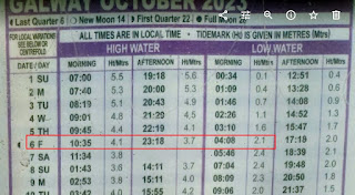
Friday low tide 2.1m at 04:08am

The moral - don't necessarily trust the internet!

So instead of a long walk to Moyard then taking the 11:40 bus 423 to Westport train station and a tight transfer to the train departing 13:10 to Heuston arriving 16:29 then the Luas and bus 65k to the end of our road, instead I retraced my route via Galway (more frequent train service than at Westport) but missed my transfer from Luas to bus 65 at the Square so had to be rescued by my son.

20190802

Now we are sixty six

So I have this free travel card which entitles me to travel anywhere on public transport in Ireland. It seems a shame to waste it so, after a good bowl of muesli and cornflakes laced with evaporated milk, I set of with my backpack at 06:30 to the end of the road where I caught the one and only bus from here to Dublin. At the Square I transferred to the Luas tram to Heuston where I took the Intercity to Mallow, then the regional service to Killarney and finally the bus to Beaufort Bridge from where I walked for two hours (10km) to Cronin's Yard where is the most popular trail head to Carrauntoohil, the highest peak in Ireland.  Since I knew I would be tight for time on the morrow, I spurned the camp site there and strode a few more km to the base of the mountain and wild camped by Lough Callee, and ate dry sandwiches and fruit cake for dinner, washed down with water.

I had chosen Thursday for my early morning climb on the basis of this excellent site which correctly prophesied:


Exiting to relieve myself during the night I was awed at the clear night sky with the Milky Way clearly visible. You don't get that where we live near to Dublin.

I woke several more times, uncomfortable and cold, then realised it was lighter - I had overslept by 20 minutes and by the time I had struck camp and set off it was 06:10. The view across the lough of my intended uphill path was somewhat intimidating at that time in the morning but, trusting I would feel better about it once I had gained some altitude and some bodily warmth, I set off, hiding my tent and sleeping bag behind a conveniently obscure rock. Breakfast (a couple of muesli bars) had to be consumed on the way.

Not surprisingly I didn't meet anyone until I started my descent, but then there was a constant stream. It is a very popular trail.

The interesting part of my climb

Showing my route back to Beaufort Bridge

Here is my track from wild campsite to summit and back to Beaufort Bridge. Stats 11.7 miles, 2.78mph average speed moving, elevation loss 1219m. To this you might add the day before's trek from Beaufort Bridge up to campsite about 13km.

This image copied from the internet

My route up was by Brother O'shea's Gully, return via Devil's Ladder. I had to do this and get back to Cronin's Yard by 10:30 in order to make connections to get me home - if I missed a connection it worked out that I'd be delayed about 5 hours. In fact I made it to Cronin's Yard by 10:20, and so was able to get the only bus that would take me to our road, and arrived home at 19:30. A hot shower, a decent meal and my bed - oh, bliss!  Although I have removed two more ticks the day after...

Oh, oh, and I had to "manage" the wound on my foot from the recent St Kevin's Way trek when I had scraped some skin off the inside of the arch of my right foot. For a bare-foot runner this is somewhat of an encumbrance. I wore sandals on the mountain climb, but the sandals chaffed the wound...

Oh, and what did I do whilst camping and hiking? I don't do earphones and constant musaz. I did listen to some audio-book whilst in the tent. But whilst hiking I enjoyed just being, and contemplated my past life. What impact has my life made? Not much, but at least I have spawned four amazing children who already far exceed my weak attempts.

The following pictures are in reverse order again. As always, click on a picture to view it full resolution, after which you should be able to scroll through the pictures.


Goodbye Heuston station

Killarney station train approaching and some interesting pants

Our train approaching Killarney station

Killarney track alignment
That Killarney is in Kerry might explain the zany arrangement. First, to get from the bus station to the train station you have to walk the long way around the block - marked in red - why could they not have provided a pedestrian bridge? Second, the train from Tralee approaches from top left of my map (yellow), and then has to reverse back into the station (waiting for the driver to walk from one end of his train to the other to do so). If only they would move the station it would solve both problems.


Curious adulation in Beaufort

Goodbye Lough Callee

Well worn trail passing Lough Callee

That's the mountain I climbed earlier

Two lakes, descending Devil's Ladder

Looking back up Devil's Ladder

Just before descending Devil's Ladder

Cnoc na Toinne (other side of Devil's Ladder)

Looking down Devil's Ladder from its top

Descent

Looking back towards the summit


Loughs Coomloughra and Eagher

More me

The sheep I mentioned

Me again

Goodbye Carrauntoohil

So soft

I suppose it grew here, like the sheep?

Glorious

Selfie

Looking around, and me

The summit in sight

Another peep at Cummeenoughter

Caher mountain

The other side of the saddle and Lough Coomloughra

The opposite peak

Carrauntoohil somewhere up there

Almost at the saddle

Scree

Further up and further in

I suppose this is thingummy's gully

Climbing above this highest lake

Beautiful Cummeenoughter Lake - I tested the water but a bit too cold

707m looking forward


At a height of 707m above sea level, Cummeenoughter Lake is the highest lake in Ireland is


707m looking back

Looking forward

Looking back

And then started going up seriously

It flattened out for a bit

See the trail?

Most folk are still in bed, missing this grandeur

The sun is up, or my camera's white balance is confused

Lough Gouragh

Getting closer - about here I hid the tent

Morning

Leaving my camp site

The morning after - almost no wind

Devil's Ladder at centre

That's the giant I have to tackle

Lough Callee, near here I camped

The trail, looking back towards Cronin's Yard

Beautiful countryside

Entering hill country

Still just me

Lots of hydrangea in these parts

Ogham stones

Some education on the way

Beaufort Bridge over River Laune

I think I mentioned I like trains?

Leaving home

Proof that it was me taking the photos