I have a Free Travel pass. There is no additional charge for a bicycle on Iarnród Éireann, but it is necessary to book a bicycle as space is limited. So I booked this trip a few days in advance choosing two days that Met Éireann assured me would be fine. But this is Ireland: on my departure day the forecast had changed to rain most of the second day.
My route was inspired by discovering the An Coinigéar or the Cunnigar, a sand spit which, we are told, has formed as a result of deposition by longshore drift, the movement of sand along the coast by the waves and the estuary emerging at the north of the bay slowing it down. As time progressed, the deposited material has formed a spit, which is 2.6 km long and which almost closes Dungarvan harbour at its northern end.
Check out these drone shots which suggest that there is much more to Cunnigar under the surface that appears to the naked eye. A bit like an ice berg.
Waking ahead of my 05:00 alarm I breakfasted hastily and mounted my trusty steed for the 2+ hour ride to Heuston, Dublin where I caught the 08:00 service for Cork. Alighting at Limerick Junction I took the so called "inter city" to Waterford which pootles through the beautiful Suir valley at a leisurely 60 to 80km/hr. Arriving at last I cycled the 46km of Waterford Greenway to Dungarvan.
Whistlestop Café, Kilmeadan Station
My plan was to luncheon at the Whistlestop Café but in the event their most excellent tea and scone (served warmed with butter and: would you like strawberry, raspberry or blackcurrant jam?) did the trick.
Arriving in Dungarvan ahead of schedule, my first port of call was Lidl where I purchased hardtack and orange juice (not wishing for Scurvy), then hung around until the F&C shop opened. Suitably fuelled I then set off for the Cunnigar.
On turning off the N25 a sign announces you are entering the Gaeltacht after which all road signs are in Gaelic only. In English An Coinigéar means "rabbit warren". This rabbit warren business: last year's Forays to Coney Island and Omey Island were also nominally overrun with rabbits. On this occasion I saw none but, instead, there were cattle freely roaming the whole peninsula - more of that later.
the Cunnigar peninsula, car park at far right
Here is a beautiful video of the Cunnigar by @fardinger:
And here are a few of my photos, or click here to view the album.
Dungarvan town from the tip of the Cunnigar
The beach on the sea side is so shallow
I was not able to ascertain whether the Cunnigar is privately or public land. There is a small public car park which bodes well, but cattle are roaming freely on the peninsular itself, which might not bode well for camping. I stumbled on a group with their tent already erected - they had tried to request permission but the locals didn't seem to know who to ask. So we didn't ask. I positioned my tent where it would not be seen from the only house visible and hoped for the best. I then walked / ran to the end of the peninsula and back (about 6km) and by then was ready for bed. I slept soundly until I woke in the dark and could here noises without: I cautiously looked out with my head-light - the cattle were investigating this new intrusion into their territory. Worried that one might stand on and buckle my bike or push the tent over, I waited watchfully but after a while they moved to pastures greener. I slept but was woken again, now dawn and a little before my alarm, by the pitter-patter of rain. There is nothing quite so charming and quintessential of camping as lying snug in one's sleeping bag whilst on the other side of the canvas the elements are raging. Of course I knew rain was coming but still I had to decide where to strike camp or wait till the weather turned. But I knew I had to go - hadn't I promised by daughter I'd be back soon after 3pm?
My planned route to Mallow: 95.9 km
I took no pictures on my return journey to Mallow because was raining most of the time. All I wanted was to complete the journey. It was long and wet and tedious and gruelling. But challenging. Had it been sunny the countryside would have been glorious, no doubt.
My route initially followed the tiny river Brickey, but "route" turned out to be a euphemism: it was in fact an badly overgrown and rather narrow farm track that my GPS had led me to. I persevered but the undergrowth wound itself around my derailleur cassette so that I could not from then on access the higher gears. Thankfully no punctures or tics. And so I arrived at Cappoquin where my route joined An Abhainn Mhór which translates to The Great River otherwise known as the Blackwater river. There are numerous Blackwater rivers in Ireland - this one is the Munster Blackwater.
I breakfasted on hardtack on the Avonmore bridge as it crosses the Blackwater, and where the river abruptly turns to the right and southwards. I would have taken a photo of the bridge but it was raining and my cell phone was wrapped in a poly-bag and I hadn't the enthusiasm to extricate it. So you'll have to be content with a stock photo.
Avonmore bridge Cappoquin, stock photo
The bridge has some history. It was a Potato Famine relief project of the Keane family and was opened in 1851 but the original name, ‘Victoria Bridge’ was later chiselled out by nationalists. The bridge was a target of attack during the Troubles of the 1920s. There is a place where an explosion required extensive repairs to be done. For all that, it was my planned route, rather than follow the probably easier going but boring N72. But all places tend towards boring in the rain.
The plan was to cross the river again at Lismore and then follow the R666 which would hug the river all the way to Fermoy, but it didn't happen. The rain.
Historic photo of Cappoquin railway bridge
Proposed Greenway
But I did notice the old railway bridge at Cappoquin and, later, numerous land-owner signs condemning the proposed Mallow to Dungarvan Greenway which would follow the old railway and, you can see, would take a similar route to my own. Greenways are now The Thing, doubtless fuelled by Covid and the Green Party. Do I approve? Largely yes because I love cycling, but only after due consultation with local land owners and, anyway, where is the money coming from? I must say that the Waterford Greenway has been a major success judging by how many folk are using it.
Using Google maps aerial view the route of much of the original railway can be traced, but so much has been lost, and it was only on 25 March 1967 that the last train ran. Very recent history: well within my lifetime.
The final stretch from Fermoy to Mallow was hard work. Even though it looked relatively flat on the map, in fact it was a continuous long up hills and ridiculously steep and bendy downhills. But I made it, and with about 20 minutes to spare before the service to Sallins/Naas via Portlaoise. Lunch on board: a squashed sandwich from home, and hardtack washed down with Irish Rail tea.
Proof of arrival at Mallow train station.
Oh - and regarding having to book a bicycle space - on the Mallow Portlaoise segment all three bicycle hooks were in use, plus a couple more bikes randomly distributed, and that before I added mine! So somebody wasn't booking, and nobody seemed to care.
As I remarked to my granddaughter, at her age the world lies at her feet, but at my age I'm thinking "can I even do this?" or " this may be the last time I get to..." But in good faith that the body the Good Lord gave me won't let me down yet, I set off for what must count as the first of my 2024 forays. The particular destination was the Suir Blueway bicycle path following the river Suir from Clonmel to Carrick on Suir and the railway linking Limerick Junction with Waterford.
Outward journey
The foray started with a 5:15am departure by bike for Heuston station, Dublin, where I boarded the 08:00 Cork service, changing at Limerick Junction to the branch line to Cahir.
Segment (1) to Heuston 42.4km
Changing trains at Limerick Junction
From Cahir I followed the wide, paved path along the river, past Swiss Cottage, until it ended abruptly. Here there is a short footpath to the nearby road, but very overgrown and full of stinging nettles. I survived.
beside the Suir, looking north towards Cahir
looking south towards Swiss Cottage
The blue-way
Forced to leave the river I fought my way to the road and biked to Clonmel (land of cider) where I joined the blue-way, so called because the river is navigable for canoes and suchlike, though I did not see any. But I did pass many walkers and cyclists on the nicely paved path. And folk fishing out in their waders - but the fishing in these parts is all private, some clubs having well appointed fishing shelters.
From Cahir to Clonmel
From Clonmel to Carrick along the blue-way, totalling 51.5km
Beautiful bridges
Orchards to feed the cider works
The paved blue-way
The tower
I had several hours to kill before my train, the only train, would return me to Limerick Junction, so after checking the whereabouts of the station (and finding it all locked up) I entered part (b) of my foray, destination De Le Poer Tower. This involved a steep climb of about 150m elevation gain over 1.5km out of the Suir valley and then another battle with undergrowth before emerging onto a forestry track beside the tower. The wonders of GPS!
16.6km there and back
Having emerged from the undergrowth...
Towards the Comeragh mountains
The top is obviously unfinished
Towards Waterford
The plaque is visible but not the inscription
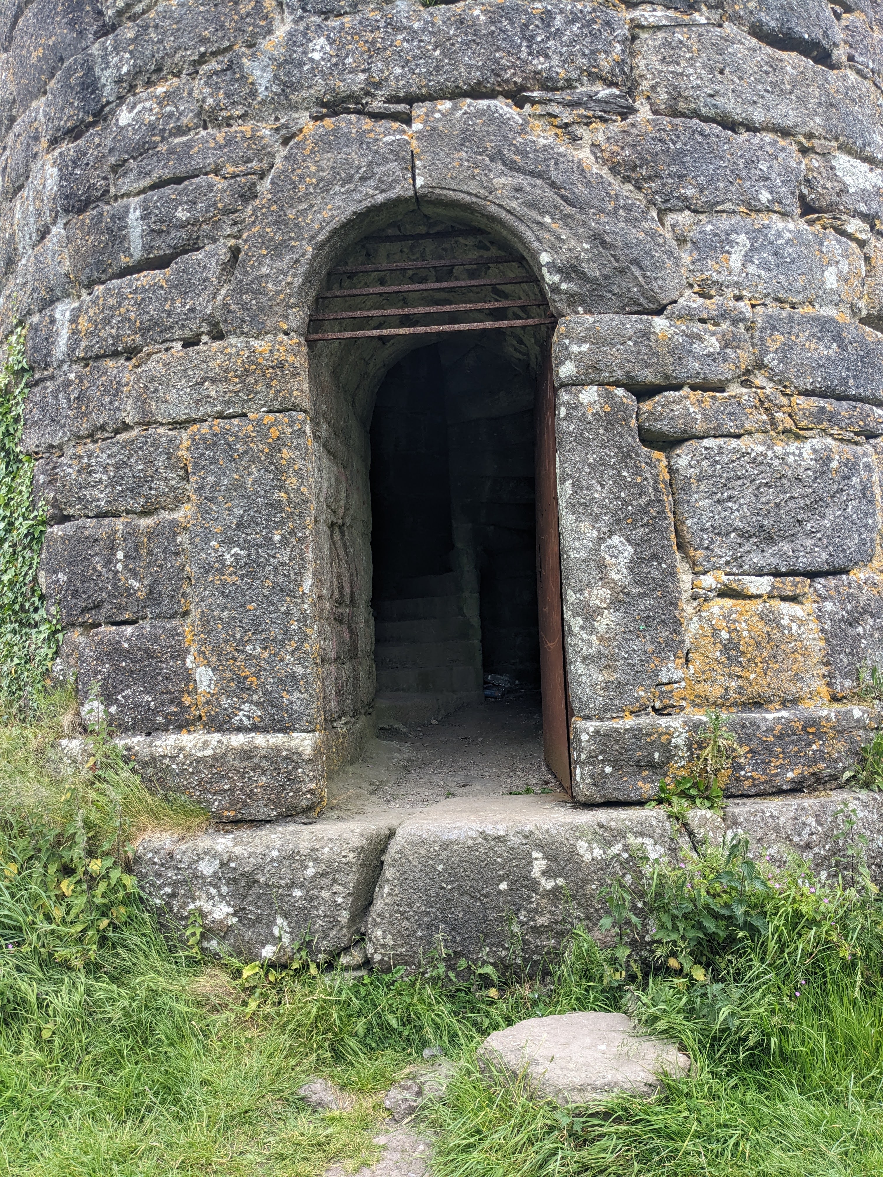
There is a steel door, but it was open
Much of the following is quoted from various internet sites.
The De Le Poer Tower has a sad back story. It was built in 1785 by the second Earl of Tyrone, George de la Poer Beresford, in memory of his eldest son Marcus. We are told that the plaque above its door states that the monument was dedicated 'To his beloved Son, his niece and his friend'. His son Marcus died aged 12 in a horse riding accident at Curraghmore. The 'friend' refers to his tutor Marcus, Charles Poliere de Botens, who died at shortly after the boy's death. It touched me that his tutor was also his friend.
Curraghmore is the estate and its big house is just visible in one of my photos. More sadness followed: the tower was planned to be 120ft high but was left unfinished at 70ft. Why? Maybe as a poignant statement of grief. Its unfinished look makes it even more special, like a symbol of a life that ended too soon; a powerful reminder of how precious life is and how memories last forever. Surprisingly in this age of safety first, the entrance is laid open and I climbed up the 92 steps to the top where the spiral staircase ends abruptly. There is no parapet or rail, nothing to stop the more adventurous from standing on the edge and falling. Indeed, at the base there is a recently erected wooden cross where, I suppose, someone lost their life that way. All very heart wrenching. But I had no time to commiserate: I had to get back to catch the one and only train. Hurrying down to the road, the undergrowth inflicting many bramble scratches on my legs, a further testament to the sorry story.
Curraghmore is the seat of the Marquess of Waterford. The estate was part of the grant of land made to Sir Roger le Puher by Henry II in 1167. One wonders on what basis Henry II could grant Irish land. Today it is the home of Curraghmore Whiskey, a 100% authentic, Single Estate Pot Still Whiskey, crafted from barley and oats grown on the estate.
My original intention was to go on to explore the estate's nearby church which I could see from the tower, and Mother Brown, a curiosity that you can do your own research on. Driven by an irrational fear of missing the train I let those historic items be and hurried back.
The tea shop
Mostly downhill, it took less time than planned to return to the railway station, indeed I discovered an error in my calculations: I actually still had over an hour spare. So I roamed the streets of Carrick in search of tea and found the unlikely named Sunnyside Café. Propping my bike against the neighbouring derelict property (Carrick is a bit run down) I was accosted by the proprietor who kindly coerced me into ordering a pot of tea and scone with butter and jam, for which I was eternally thankful. Who wouldn't be after peddling up that hill?
The railway
Then back to the station. It was still locked up, after all it serves only two trains in each direction every day. But eventually the signal man cum porter cum station master unlocked the gate and led me to a waiting room complete with electric heater. I still had half and hour or so to wait so I familiarised myself with things railway.
Carrick on Suir station towards Waterford
Section signal protecting the level crossing
Signal boxes are still in use on this line
The level crossing gates are opened manually
home signal 'off' shows our train is on the way
Gates closed to traffic and section signal 'off'
Our train arrives at last!
One of our stops is this iconic placename
Having I suppose ascertained that the train is running on time and that the section ahead is clear, just before the due time of arrival the signal man descends from his box and drives his car the 200m or so to the level crossing. He manually closes the gate to traffic, then drives back to his box where he lowers the section signal to indicate to the arriving train that it is safe to proceed. He then climbs down from his box again, carrying the block signalling token to give to the train driver. By this time I am in the train, but doubtless the signal man communicates with the next box that the train has entered the section, sets the signal 'on' (stop), drives down to the crossing gates and opens them, then closes up shop and takes a well earned rest. Which melodrama all seems a bit OTT given that there is likely only one train set that trundles from end to end of the route.
On the return journey I noticed that there are a number of similarly manually operated level crossing on this line, complete with signal boxes, although I noticed that one crossing was automated with lifting barriers and colour-light signals protecting it. I suppose it warranted this special treatment because it was a busier road.
Based on the appearance of the track (concrete sleepers, welded rail, clean ballast), Iarnród Éireann has obviously spent a small fortune on bringing the line up to standard so one wonders why so few trains each day and so few folk using those trains. I was surprised to find semaphore signalling, indeed the signals look brand new so I suppose they also were upgraded. And why the 80km/hr speed limit? I do hope the line stays open because I like branch lines. I went to school on one. But at present it surely cannot be economical. One blogger sums it up with "It is like spending a fortune upgrading a hotel but only opening on a Wednesday during the depths of winter".
Once again I managed to convey my bike from train to train at Limerick Junction and then again at Portlaoise catching the slow train that would stop at Sallins. Here I exited to cycle the last segment of my trip back home. A total of 131.9 km biking.