 |
| The raison d'etre |
Following my post on Coney Island, my son-in-law asked if I knew about Omey Island, similarly accessed by a natural tidal causeway. I didn't, but not for very long - I did my research and figured the beginning of this week was good for weather and tides and so off I set.
 |
| Behold - it actually fits! |
And besides, my son from across the ocean had recently sent me a new tent, a North Face Stormbreak 1 and of course it needed to be tried out. Initial assessment was positive: it packs up into a cylindrical shape that is shorter than with my existing tent and thus actually just fits inside my small backpack, and it is 0.3kg lighter. Although similar in its X-pole design it is easier to set up because the poles are erected first and the main sheet is clipped to and hangs under the arched poles. Whereas with my old tent you had to thread the poles through channels and only then erect them. The new tent has a separate fly sheet that goes over the poles, good for keeping rain out. It did rain a bit during my one night tent-over and I remained perfectly dry in my cocoon inside. I totally recommend this tent, although it could do with a couple more tent pegs.

The red rectangle on the right is home and the one on the left is Omey Island, off the Connemara coast. Starting with the Dublin Galway train service, I figured two possible routes: hike or bike. Since it might be difficult to take a bike on a bus, and since it is not nice biking in the dark (I'd have to had left home at 05:30), I opted on the former. Maybe next year I'll try the bike option when the days are longer.
Bus 65 from home to Tallaght (Dublin), Luas tram to Heuston train station, Inter-city service to Galway town, two delightful hours by road through the Connemara National Park on bus 923 to Cleggan and, finally, Shanks's pony for the last 90 minutes to Omey where I found, as I had expected, the tide low enough to cross. The causeway is shorter than that for Coney Island, although the island itself is larger.
 |
| My camp site |
The red rectangle is the approximate site of my tent. Counter-intuitively there is a large lake in the middle of the island. I mused: if in this lake there was a smaller island, and in that island a yet smaller lake and so on ad infinitum...
About half of the island's area is fenced farmland, leaving the remaining half free for roaming. On arrival there was a notice listing all the things you are not allowed to do. Camping was one. But I had come all the way from Dublin and was hardly going to retreat that easily so I tacitly ignored the sign and no one seemed to mind. I do of course strictly obey the "leave no trace" rule of wild camping.
The island did not disappoint. There are several beaches, a hilly bit in the middle, the ruins of a
church that was dug out from the sand dunes in 1981, and a notable lack of People. Oh, and rabbits galore (unlike Coney Island). What more could you ask for?
Chicken sandwich for lunch and the same for dinner, and up at 06:15 the next day for a quick breakfast of fruit cake and CDM, early in order to catch the tide, or so I thought. I packed up in the dark and set off, but when I got to the causeway, lo-and-behold the water was high and still rising - already too high to cross safely. After consulting various web sites, and calling my wife who confirmed my reading of the tide charts, I made a water mark with some stones and turned around to circumnavigate the island once more. A bit chilly for swimming. When I got back the water had clearly receded and was still going out. So I ventured across: the maximum depth about 20cm.
The thing was, I had consulted more than one tide charts which agreed with each other in my research before the trip. Agreed with each other but apparently not with reality.
On the date of my crossing, Tuesday 3 October, this site was claiming low tide at 07:43am, which was pretty close to my arrival. But after being confronted with reality, I eventually found the truth. But the truth upset my itinerary.
The following illustrates the problem, on Friday 6th which was a few days after my trip :
 |
| Friday 6th high tide 3.54m a 4:25am |
 |
| Friday low tide 1.84m at 04:18am |
And finally, having crossed at around 11:30, I saw a notice in the small car park that also gave the truth, pretty close to the above. Pity I didn't consult this chart on the way out!
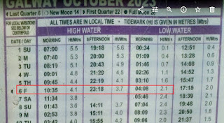 |
| Friday low tide 2.1m at 04:08am |
The moral - don't necessarily trust the internet!
So instead of a long walk to Moyard then taking the 11:40 bus 423 to Westport train station and a tight transfer to the train departing 13:10 to Heuston arriving 16:29 then the Luas and bus 65k to the end of our road, instead I retraced my route via Galway (more frequent train service than at Westport) but missed my transfer from Luas to bus 65 at the Square so had to be rescued by my son.


No comments:
Post a Comment