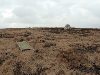
Here's a map from the web site where I found the picture of the new cairn, and here's another picture of the cairn and the stretcher those brave souls used to move the stones. The map clearly shows Silsean as the southerly peak and that was the one I climbed. Anyway it had the same shape cairn on it. My OS map also agrees with the above. So I don't think there is any dispute about where I was standing.
Here, incidentally, is what it looked like a few years ago before these good souls built the cairn and when the top was marked by a post. You can see how churned up it was by the 4-wheelers or whatever. It is still churned up around the cairn but not anywhere near as bad.
But now take a look here. This appears to be a reputable site. To save you time here is the salient part:
Moanbane / Silsean - Which is which? I spent some time enquiring into this and the evidence points to Silshean or Shilshean being the northern end. Firstly, the OS letters for Wicklow record a Silshaw Brook in 1838, to immediate north of mountain. Liam Price says that the northern end is known locally as Shilshean in the 1940's. Seamus MacDonnell from Kylebeg, a local hill farmer who grew up in the area, told me that he thought Silsean was the northern end in Feb 2010. It's not clear entirely what Shileshean derives from - Price speculates that it may be connected to Solais or Soilse - Soillseán - a place of light. The Shiney Flags glen may have an echo of this and be related to the name - the shine or light is from from water glistening as it flows down the rocky slabs. Moanbane could be from Móin Bhán - the white or fair coloured bog (bog cotton or pale sedges) but there are other possibilities: it is also worth noting that the SE end of the hill is most associated with turf cutting - the Black Banks. I enquired also in King's River Valley and the name Shilshean or variants doesn't seem to be known there - it'd be over the other side of the hill. They just called the whole hill, Moanbane - so perhaps Moanbane applies to the hill as a whole with Silsean being the northern end or side. I suspect that the confusion arises in a similar fashion to Corrigasleggaun above, the first editions of the OSI sheet 56 carried forward what appeared on the old Wicklow One Inch map - Moanbane as the NE top, no name on the SE top. Hillwalkers have long been aware of the name Silsean (from Price presumably) as being associated with one of the tops but given that the NE top was labelled Moanbane, assumed this was correct and that Silsean by default must be the SE end. The name was supplied to OSI when feedback was requested after the 1st edition of sheet 56 was published - who also labelled it on the SE end. But the evidence points to erroneous assumptions being made and careful checking of the record points to Shilshean being the NE end of this hill.
So now I am altogether confused - was I standing on Silsean or was it in fact Moanbane?


No comments:
Post a Comment